Using Remote Sensing and GIS to Analyze NDVI Values for Darfur, Sudan
Average NDVI values derived from MODIS Terra satellite data of western Sudan (Darfur) were compared for the years 2000 to 2008. A monthly average for the wetter than normal year 2008 was also analyzed.
These showed an increased vigor despite lower than average rainfall. This can be attributed to changing land use patterns. Plant species previously limited by livestock were no longer being grazed due to forced migration of the herding tribes. Refugee camps could also be identified by much lower NDVI than nearby surrounding areas.
Remote sensing (images) also documented many destroyed villages.
Frequent armed conflicts, poor health indicators, lack of social services and recurrent natural disasters have pushed Sudan to a critical point from the humanitarian perspective. Food insecurity in Sudan is a serious threat, and acute malnutrition is at a dangerous level. Child and maternal mortality rates remain high. The current unrest surrounding Southern Sudan's independence exacerbates the threats to children. (unicef)
Desertification - is defined as "land degradation in arid, semi-arid and dry sub-humid areas resulting from various factors, including climatic variations and human activities"
A drought is an extended period of months or years when a region notes a deficiency in its water supply. (generally precipitation)
Sudan with its large area and diversified ecosystems reflects different types of land use. The intensive use of the available natural resources has led to the appearance of the problem of desertification. In Sudan, desertification is regarded as the first environmental threat that poses a real constraint to achieving sustainable agricultural
development of drylands.
(United Nations Convention on Combating Desertification report - 2004
Satellite imagery product MODIS Terra and remote sensing application Normalized Difference Vegetation Index (NDVI) was the primary means for measuring land cover change and vegetation health.
Terra Earth Observation Sattelite Figure 1. Artist's rendering of the Terra spacecraft. Image cerdit (NASA)
MODIS (or Moderate Resolution Imaging Spectroradiometer) is a key instrument aboard the Terra (EOS AM) satellite.Terra MODIS aquires data in 36 spectral bands, or groups of wavelengths 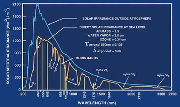
Solar irradiance spectrum and MODIS bands.
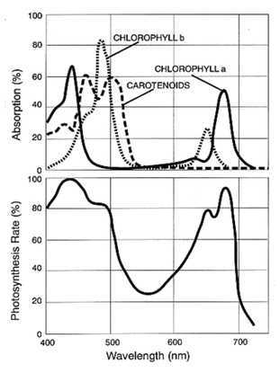
Typical PAR action spectrum, shown beside absorption spectra for chlorophyll-A, chlorophyll-B, and carotenoids
|
Normalized Difference Vegetation Index (NDVI)Live green plants absorb solar radiation in the photosynthetically active radiation (PAR) spectral region, which they use as a source of energy in the process of photosynthesis. Leaf cells have also evolved to scatter (i.e., reflect and transmit) solar radiation in the near-infrared spectral region (which carries approximately half of the total incoming solar energy), because the energy level per photon in that domain (wavelengths longer than about 700 nanometers) is not sufficient to be useful to synthesize organic molecules. A strong absorption at these wavelengths would only result in overheating the plant and possibly damaging the tissues. Hence, live green plants appear relatively dark in the PAR and relatively bright in the near-infrared. By contrast, clouds and snow tend to be rather bright in the red (as well as other visible wavelengths) and quite dark in the near-infrared. The pigment in plant leaves, chlorophyll, strongly absorbs visible light (from 0.4 to 0.7 µm) for use in photosynthesis. The cell structure of the leaves, on the other hand, strongly reflects near-infrared light (from 0.7 to 1.1 µm). The more leaves a plant has, the more these wavelengths of light are affected, respectively. Since early instruments of Earth Observation, such as NASA's ERTS and NOAA's AVHRR, acquired data in visible and near-infrared, it was natural to exploit the strong differences in plant reflectance to determine their spatial distribution in these satellite images.
The NDVI is calculated from these individual measurements as follows: NDVI = (NIR-VIZ) / ( NIR + VIZ ) where VIS and NIR stand for the spectral reflectance measurements acquired in the visible (red) and near-infrared regions, respectively . These spectral reflectances are themselves ratios of the reflected over the incoming radiation in each spectral band individually, hence they take on values between 0.0 and 1.0. By design, the NDVI itself thus varies between -1.0 and +1.0. It should be noted that NDVI is functionally, but not linearly, equivalent to the simple infrared/red ratio (NIR/VIS). The advantage of NDVI over a simple infrared/red ratio is therefore generally limited to any possible linearity of its functional relationship with vegetation properties (e.g. biomass). The simple ratio (unlike NDVI) is always positive, which may have practical advantages, but it also has a mathematically infinite range (0 to infinity), which can be a practical disadvantage as compared to NDVI. Also in this regard, note that the VIS term in the numerator of NDVI only scales the result, thereby creating negative values. NDVI is functionally and linearly equivalent to the ratio NIR / (NIR+VIS), which ranges from 0 to 1 and is thus never negative nor limitless in range. But the most important concept in the understanding of the NDVI algebraic formula is that, despite its name, it is a transformation of a spectral ratio (NIR/VIS), and it has no functional relationship to a spectral difference (NIR-VIS). In general, if there is much more reflected radiation in near-infrared wavelengths than in visible wavelengths, then the vegetation in that pixel is likely to be dense and may contain some type of forest. Subsequent work has shown that the NDVI is directly related to the photosynthetic capacity and hence energy absorption of plant canopies. (Wikipedia) Using two independent satellite imagery products, MODIS Terra and SPOT Vegetation this paper documents change to land cover, primarily vegetation from 1998 through 2007 in the regions of Darfur most impacted by the genocide since 2003. Its findings show a steadily increasing return of natural vegetation coverage and vigor, likely grasses and shrubs, in formerly agrarian and livestock grazing ranges, since 2004. This environmental recovery is demonstrably not a result of increased rainfall, but of the abrupt change in land use directly related to the systematic violence committed by Sudanese government and militia forces against the peoples of Darfur. In an agriculture-based society, this vegetation rebound resulted from the loss of livestock and the inability to farm, caused by human displacement and the destruction of subsistence resources from 2003 to 2007. (Yale University Genocide Studies Working Paper No. 36 Author: Russell Schimmer) Yale University Genocide Studies Program, Remote Sensing Project |
The Effects of Grazing on Vegetation Cycles
A change in vegetation vigor and coverage is likely not a function of an emerging new species but rather signals the increasing vigor of existing species. This is likely the result of newly limited livestock grazing: plant species previously consumed by livestock before reaching full growth were by 2006-07 no longer impacted by grazing. For example, in 2000-03 Vegetation Class 3 occupied pixels that by 2006-07 were replaced by Vegetation Class 23. Because these two classes share somewhat similar growing cycles and only differ considerably in NDVI magnitude, they are probably the same species of grass, which has not been affected by grazing.
The findings illustrate a steady rebound of vegetation coverage and vigor in much of west-central and north-central Darfur since 2003, despite a continuing decrease in annual rainfall. Furthermore, the influences of rainfall and livestock grazing on vegetation vigor are distinguishable. A greatly decreased number of livestock is likely the main factor driving this rebound in biomass. Because of the continual violence from 2003 through 2007, livestock herds might be kept further south in Darfur or elsewhere but there is little evidence that highly concentrated herds of any great number remained in the study area by 2007. The remote sensing findings support the assumption that the displacement of people and the decline of livestock in a region are uniquely related. Hence, tracking temporal and spatial changes to land cover as a function of land use can contribute evidence about the systematic governmentsponsored violence and population displacement, which are characteristic of the genocide in Darfur.
( Yale University Genocide Studies Program, Remote Sensing Project)
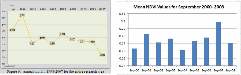
Despite reduction in rainfall, NDVI increased.
Conflict
From time immemorial, seasonal fluctuations in water and grazing land had led to conflict over natural resources in Darfur. These tensions exploded into a Fur-Arab war in 1987 after drought and famine in North Darfur drove many Arabs south towards Fur lands in South Darfur. Earlier conflicts had been settled by traditional reconciliation mechanisms. But these had been weakened by a series of measures beginning in 1971, when President Gaafar Nimeiri abolished the tribal-based Native Administration. Conflicts and insecurity escalated in rural areas as those with access to firearms took the law into their own hands and started resolving their disputes by force rather than by mediation.
From the mid-1980s to the outbreak of rebellion in 2003, Darfur suffered high-intensity, large-scale armed conflicts fought with modern weapons - many of them brought across Darfur's long and virtually unpoliced desert borders with Chad and Libya. When Arab nomads attempted to occupy traditional Fur land with the support of the government, the Fur responded with the mass burning of pastureland.
Initial recruits to the government war in 2003 came mainly from two Arab groups - the failed nomads of North Darfur, and immigrants from Chad without land of their own. With the exception of urban areas, almost all land in Darfur is utilized according to a customary tenure or hakura system of land grants initially conferred by the Fur sultans. In South Darfur, the sultans gave hakuras to each of the four main cattle-herding or Baggara Arab tribes - the Rizeigat, Ta'aisha, Beni Halba and Habbaniya. The camel-herding Abbala of North Darfur received no land but were allowed right of passage though the tribal lands of sedentary groups.
The Crisis At-a-Glance People who have died as a direct result of the conflict: Over 200,000 People displaced from Darfur: Over 2 million People displaced from Darfur into Chad: 260,000 Displaced Chadians: 160,000 People displaced from the Central African Republic: 155,000 TOTAL at risk: Several million When war erupted in 2003, most Arab tribes with land remained neutral. But many landless Abbala joined the Janjawid, believing that land occupied by force would be theirs.
Government forces and Janjawid emptied wide swathes of land with a scorched-earth campaign war that destroyed everything that made life possible, including wells, pumps, orchards and mosques. As international criticism of the conflict grew, the Sudanese Army took a back seat and the militias became the spearhead of the government's strategy, as they had in southern Sudan. (Eyes on Darfur)
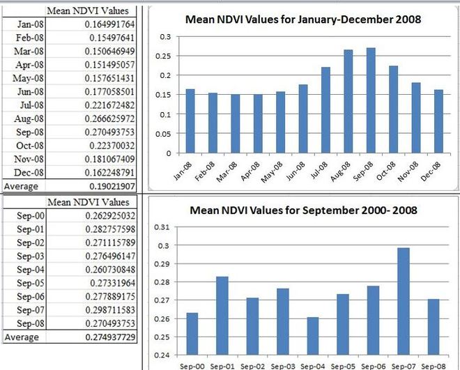
The MODIS mean NDVI values used in this investigation

Maps and chart showing the monthly change in NDVI in 2008
|

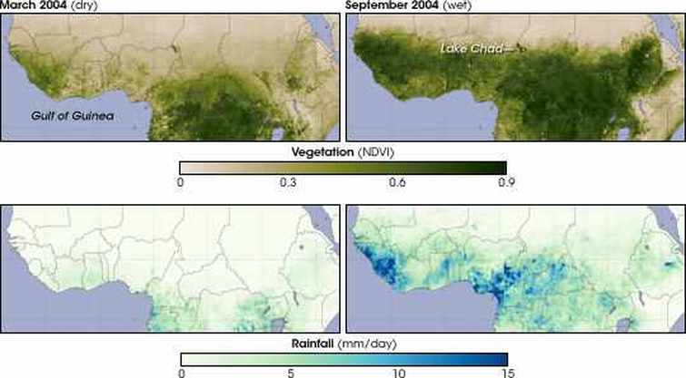
Map contrasting the low NDVI (2004) and the high NDVI (2008) during the wet month of September.
|
OIL
The government armed and deployed militias to combat the rebel threat to oil development. The militias were primarily Arab cattle-herders, Baggara, from western and
northern Kordofan and Darfur, known as murahaleen (nomadic raiders). In the late 1980s and 1990s, Baggara from south Darfur and south Kordofan served as government militia in Bahr el-Ghazal, and systematically raided cattle stocks of the inhabitants of the oil-rich areas, mostly Nuer and Dinka tribes people. These systematic atrocities committed by the government-sponsored Baggara are hauntingly similar to those later committed by the Janjawiid. But we have no evidence of Sudanese government advance plans to target the livestock of African communities in Darfur. Livestock looting may have been a lucrative byproduct of the counter-insurgency campaign.
U.N. Resolution 1769
On July 31, 2007, the United Nations Security Council passed Resolution 1769, which was intended to resolve the Darfur conflict. It called for the creation of a joint 26,000 UNAU (UNAMID) ground force to establish peace in Darfur, replacing the 7,000-member African Union Mission in Sudan. China’s vote in favor of this resolution was widely hailed. On December 31, the first U.N. forces deployed in Darfur. As of January 31, 2008, the U.N. reported 9,080 uniformed personnel deployed, including 7,156 troops, 220 military observers, and 1,704 police officers, supported by 66 United Nations Volunteers. According to the news agency Agence France-Presse (AFP), as of April 10, 2008, only 1,562 police officers serving in UNAMID have been deployed, far short of the 6,372 police that are supposed to deploy as part of the peacekeeping mission.
China’s role in Darfur has been neither marginal, nor direct. Early in the conflict, China reportedly supported Sudan militarily. Furthermore, until Resolution 1769, which China helped broker with Khartoum, Beijing had frustrated direct U.N. involvement in Darfur. Under 1769, however, members of the People’s Liberation Army (PLA) will be part of the U.N. deployment to Darfur. The SLA and JEM rebels have reacted violently to China’s growing involvement in Darfur, and have issued warnings.
In October 2007, JEM forces attacked the Chinese-owned Greater Nile Petroleum Operating Company (GNPOC) oil fields in southeastern Darfur, which featured hostage-taking and a week-long ultimatum to Beijing to withdraw—described by JEM as “a message to the Chinese companies in particular.” In reaction to Chinese participation in the UN–AU Mission in Darfur (UNAMID), the Sudan Liberation Movement’s commander for North Darfur, Suleiman Marjan, said “all Darfur is hostile to their presence.” Khalil Ibrahim, leader of JEM, reiterated his call on China to “quit Sudan”: “I am not saying I will attack them. I will not say I will not attack them. What I am saying is that they are taking our oil for blood.”
[There is] a direct correlation between the displacement of local populations and the looting of livestock, as evidenced in the rebound of vegetation coverage and vigor in the research area. In Part II, we report evidence that the disruption of seasonal grazing patterns due to the violence likely contributed to this rebound in vegetation by
2007. Prior to the genocide in Darfur, 80 percent of Darfur’s economy relied on agricultural activities, primarily livestock. This loss of livestock has had an enormous impact on the peoples of Darfur. The post-2002 violence has disrupted traditional land use patterns and directly damaged land cover. These findings strongly suggest that much of the population of Darfur has been displaced from their normal habitats, and economic and subsistence means. The overall rebound of vegetation throughout the impacted regions of Darfur, most evident in 2007, is likely the result of two factors: a decrease in overall livestock numbers in Darfur and the difficulty of resettlement under an ongoing threat of violence. Because 2007 also saw the lowest rainfall in more than a decade, traditional land use has been dramatically
altered. The livestock wealth has disappeared and, according to recent reports, much of Darfur is facing famine.120 The rebound of vegetation is a result not of intensified agrarian activities, but of depopulation.
The recent fractionalization among tribal affiliations within the Janjawiid could possibly be a result of a renewed competition for resources. Because of the dramatically
diminished number of livestock in Darfur and limited rearing activity to restock the herds, livestock looting is no longer a lucrative byproduct of the violence. Hence, there is little remaining of economic and subsistence value. The short-term financial gain was primarily in stolen livestock. If Khartoum’s intent is to clear Darfur of non-Arabs in order to resettle Arab semisedentary pastoralists and farmers, this will take time and investment to restock herds and secure territory. Meanwhile, Khartoum has divided, relocated, and is slowly conquering the tribes of Darfur, clearing a path for oil exploitation controlled entirely by Khartoum and its multinational investors.
But more than just monitoring the effects of genocide on the environment in Darfur, our research also shows that it is possible to study the influences of climate and land use on a fragile environment using remote sensing applications. For future research into the prevention of genocide, these types of applications can be useful in understanding and quantifying the factors contributing to environmental strains that can cause violence associated with competition for diminishing resources. If preventive measures can be implemented and enforced based on an understanding of these factors, it might be possible to avoid acts of genocide.
Yale University Genocide Studies Working Paper No. 36
Sources
Yale University Genocide Studies Program, Remote Sensing Project
Tracking the Genocide in Darfur: Population Displacement as Recorded by Remote Sensing
(Genocide Studies Program at Yale University)
Report of United Nations Convention to Combat Desertification (UNCCD)
Sudan (2004 eng.) pdf
http://www.yale.edu/gsp/gis-files/darfur/Tracking-Genocide-in-Darfur-by-Remote-Sensing_No.36.pdf
Genocide Studies Working Paper No. 36
Author: Russell Schimmer
Remote Sensing Technical Advisor: Roland A. Geerken
Project Director: Ben Kiernan
http://www.eyesondarfur.org/
http://earthobservatory.nasa.gov/Features/DroughtFacts/
http://earthobservatory.nasa.gov/Features/Desertification/
http://earthobservatory.nasa.gov/Features/MeasuringVegetation/printall.php
http://www.amnestyusa.org/our-work/countries/africa/sudan
http://www.unmultimedia.org/radio/english/2011/09/land-degradation-affects-1-5-billion-people/
http://www.geostories.org/story/famine-in-the-horn-of-africa/ges879C1E16C94248687
http://www.fews.net/Pages/Horn-of-Africa-Emergency.aspx
