
Earthquake Hazards along the Wasatch Fault
The Wasatch Fault is an earthquake fault located primarily on the western edge of the Wasatch Mountains in the U.S. state of Utah. The fault is 240 miles long, stretching from southern Idaho, through northern Utah, before terminating in central Utah near the town of Fayette. It is made up of several segments, on average 25 miles long, each of which can independently produce earthquakes as powerful as local magnitude 7.5.
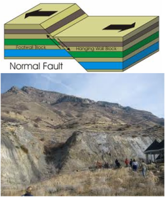
The Wasatch Fault is a normal (vertical motion) fault which forms the eastern boundary of the Basin and Range geologic province which comprises the geographic Great Basin. The Wasatch Mountains have been uplifted and tilted to the east by movement of the fault. The average rate of uplift along the fault over its history is approximately 1 mm per year, although there are indications that more rapid slip has occurred in the past few thousand years. The fault, however, does not continually slowly slip; instead, it remains locked for hundreds to thousands of years until approximately 1 to 4 meters of slip occurs rapidly, producing a strong earthquake.
The Wasatch Fault is a normal (vertical motion) fault which forms the eastern boundary of the Basin and Range geologic province which comprises the geographic Great Basin. The Wasatch Mountains have been uplifted and tilted to the east by movement of the fault. The average rate of uplift along the fault over its history is approximately 1 mm per year, although there are indications that more rapid slip has occurred in the past few thousand years. The fault, however, does not continually slowly slip; instead, it remains locked for hundreds to thousands of years until approximately 1 to 4 meters of slip occurs rapidly, producing a strong earthquake.
History of Earthquakes on the Wasatch Fault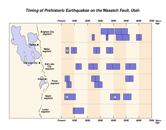
The Wasatch Fault http://geology.utah.gov/online/pdf/pi-40.pdf
Utah Department of Natural Resources (opens in a new window) |
The Wasatch Fault is a normal (vertical motion) fault which forms the eastern boundary of the Basin and Range geologic province which comprises the geographic Great Basin.
|
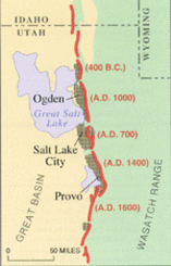
Geological history During the past 6,000 years, a strong earthquake (magnitude greater than 6.5) has occurred approximately once every 350 years somewhere along one of the central segments of the Wasatch Fault. The segments that underlie Salt Lake City and Provo produce a large earthquake on average every 1,300 years. The last major earthquake on the Salt Lake City segment was about 1,300 years ago, and on adjoining segments around 2,100 years ago. Experts note that the fault is overdue for another major earthquake, and media coverage of the threat has increased in recent years, bringing greater awareness of the threat to residents of the region. As awareness has increased since the 1980s, many key structures in the region have been undergoing extensive seismic retrofitting, reservoirs on the fault have been drained, and development in at-risk areas curtailed.[2] The urban areas of the Wasatch Front lie on soft lake sediments, a remnant of Lake Bonneville. During strong earthquakes, this sediment will cause soil liquefaction, which acts as quicksand. An earthquake on the Wasatch Fault could severely damage gas, electric, water, communication, and transportation lifelines, crippling the 2,000,000-strong Wasatch Front urban area.[3]
A recent report released by Bob Carey of Utah's Office of Emergency Services and published by the Deseret Morning News in April 2006 predicts what the possible results of a 7.0 earthquake directly hitting the Salt Lake Valley could be. The report predicts that when the quake strikes, it could kill up to 6,200 people, injure at least 90,000, and cause $40 billion USD in economic losses. At least 42% of all buildings along the Wasatch Front could be at least moderately damaged. The earthquake danger was not known when many structures were built in the area, as many hospitals and schools are located atop the faults themselves. About 50% of hospital beds could be eliminated during a quake and the region has about 200,000 unreinforced masonry buildings – buildings particularly vulnerable to shaking – compared to California state's 25,000. Massive landslides are another major threat.
From Wikipedia
Hazards
Hazards that result from earthquakes are ground shaking, ground deformation, liquefaction, and fire. Earthquakes really pose little direct danger to a person. People can't be shaken to death by an earthquake. Some movies show scenes with the ground suddenly opening up and people falling into fiery pits, but this just doesn't happen in real life.
The Effect of Ground Shaking
The Effect of Ground Shaking
Ground Shaking and Deformation
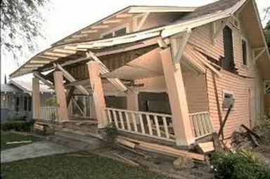
The first main earthquake hazard (danger) is the effect of ground shaking. Buildings can be damaged by the shaking itself or by the ground beneath them settling to a different level than it was before the earthquake (subsidence).
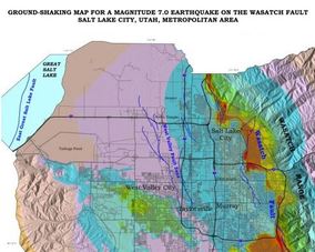
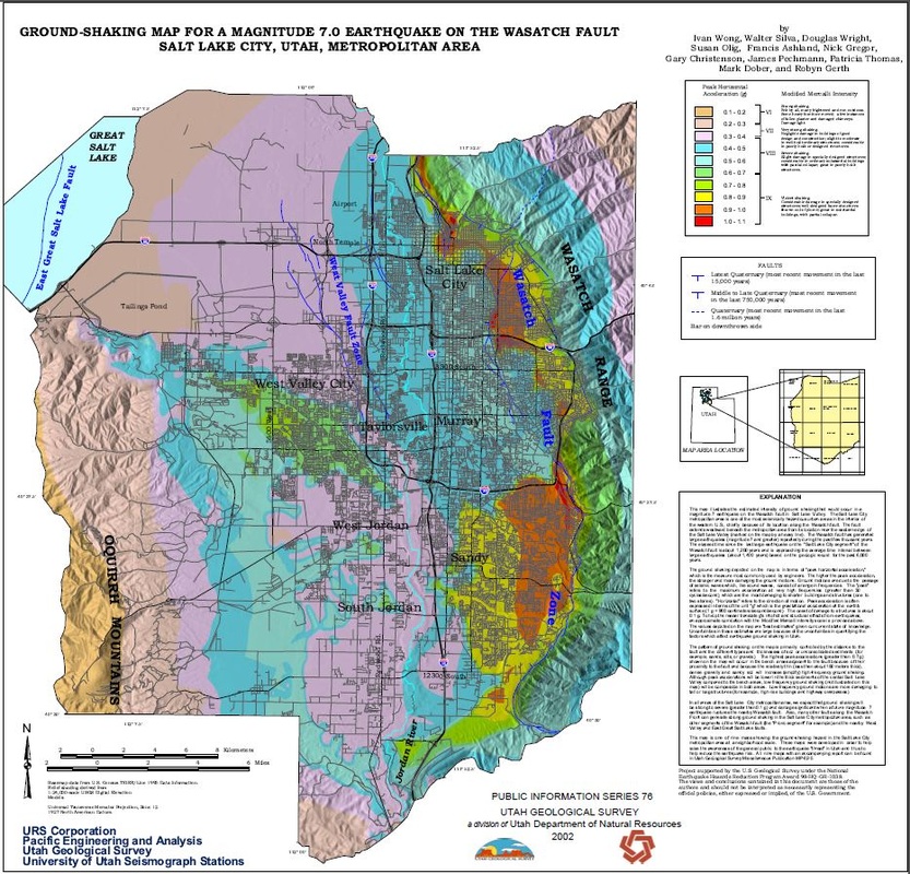
Figure 1 - Ground-Shaking map for a magnitude 7 earthquake on the
Wasatch Fault - Salt Lake City segment. Utah Department of Natural Resources
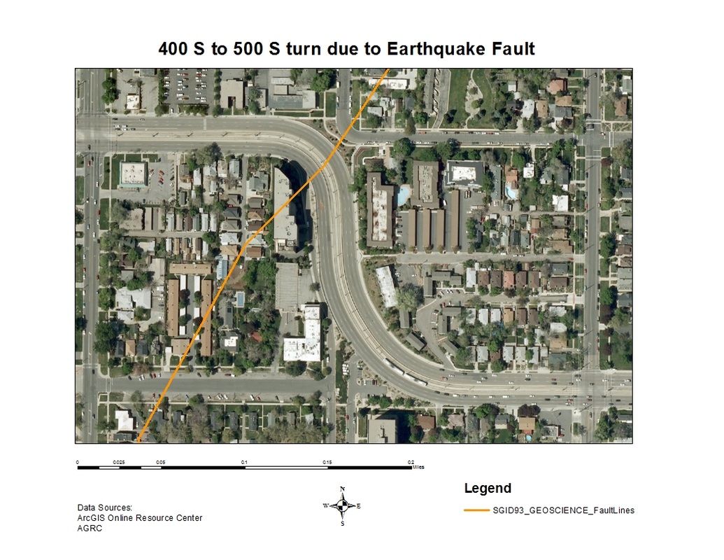
The second main earthquake hazard is ground displacement (ground movement) along a fault. If a structure (a building, road, etc.) is built across a fault, the ground displacement during an earthquake could seriously damage or rip apart that structure.
The third main hazard is flooding. An earthquake can rupture (break) dams or levees along a river. The water from the river or the reservoir would then flood the area, damaging buildings and maybe sweeping away or drowning people.
Most of the hazards to people come from man-made structures themselves and the shaking they receive from the earthquake. The real dangers to people are being crushed in a collapsing building, drowning in a flood caused by a broken dam or levee, getting buried in a landslide or burned in a fire.
Figure 1 - Ground-Shaking map for a magnitude 7 earthquake on the
Wasatch Fault - Salt Lake City segment. Utah Department of Natural Resources
The second main earthquake hazard is ground displacement (ground movement) along a fault. If a structure (a building, road, etc.) is built across a fault, the ground displacement during an earthquake could seriously damage or rip apart that structure.
The third main hazard is flooding. An earthquake can rupture (break) dams or levees along a river. The water from the river or the reservoir would then flood the area, damaging buildings and maybe sweeping away or drowning people.
Most of the hazards to people come from man-made structures themselves and the shaking they receive from the earthquake. The real dangers to people are being crushed in a collapsing building, drowning in a flood caused by a broken dam or levee, getting buried in a landslide or burned in a fire.
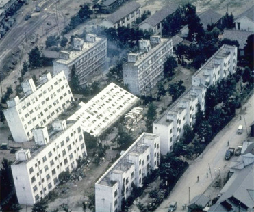 Buildings can even sink into the ground if soil liquefaction occurs. These buildings in Japan toppled when the soil underwent liquefaction
|
 Ground displacement (ground movement) along a fault
|
Fire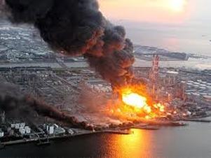
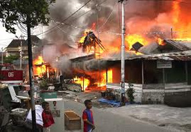
The fourth main earthquake hazard is fire. These fires can be started by broken gas lines and power lines, or tipped over wood or coal stoves. They can be a serious problem, especially if the water lines that feed the fire hydrants are broken, too. For example, after the Great San Francisco Earthquake in 1906, the city burned for three days. Most of the city was destroyed and 250,000 people were left homeless. Natural gas storage tanks burned at the Cosmo oil refinery in Ichihara city, Chiba Prefecture, near Tokyo March 11, 2011.
Figure 6 - Cosmo oil refinery in Ichihara city burned out of control with 100-foot high flames whipping into the sky. |
|
Liquefaction
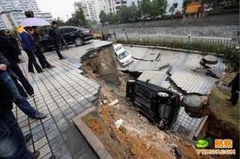
Liquefaction is the mixing of sand or soil and groundwater (water underground) during the shaking of a moderate or strong earthquake. When the water and soil are mixed, the ground becomes very soft and acts similar to quicksand. If liquefaction occurs under a building, it may start to lean, tip over, or sink several feet. The ground firms up again after the earthquake has past and the water has settled back down to its usual place deeper in the ground. Liquefaction is a hazard in areas that have groundwater near the surface and sandy soil.
Liquefaction may occur when water-saturated sandy soils are subjected to earthquake ground shaking. When soil liquefies, it loses strength and behaves as a viscous liquid (like quicksand) rather than as a solid. This can cause buildings to sink into the ground or tilt, empty buried tanks to rise to the ground surface, slope failures, nearly level ground to shift laterally tens of feet (lateral spreading), surface subsidence, ground cracking, and sand blows.
Liquefaction may occur when water-saturated sandy soils are subjected to earthquake ground shaking. When soil liquefies, it loses strength and behaves as a viscous liquid (like quicksand) rather than as a solid. This can cause buildings to sink into the ground or tilt, empty buried tanks to rise to the ground surface, slope failures, nearly level ground to shift laterally tens of feet (lateral spreading), surface subsidence, ground cracking, and sand blows.
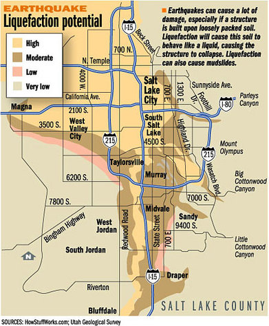
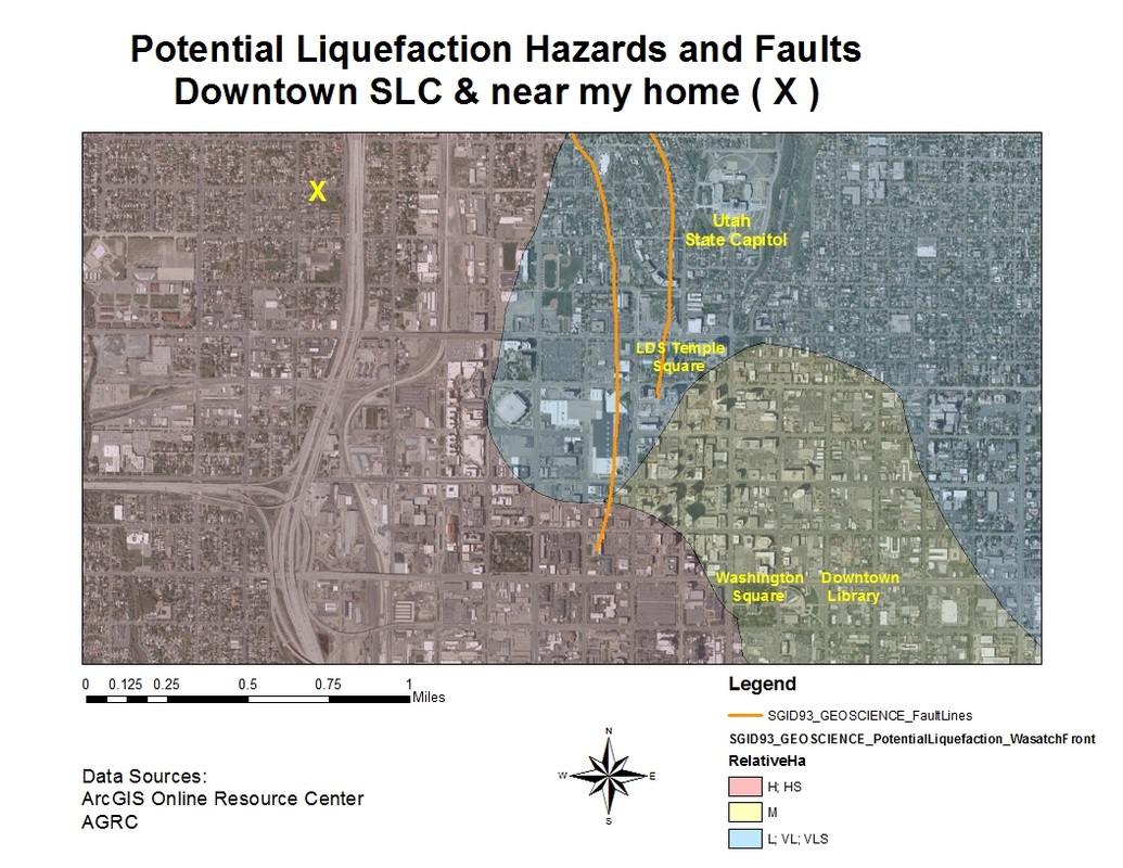
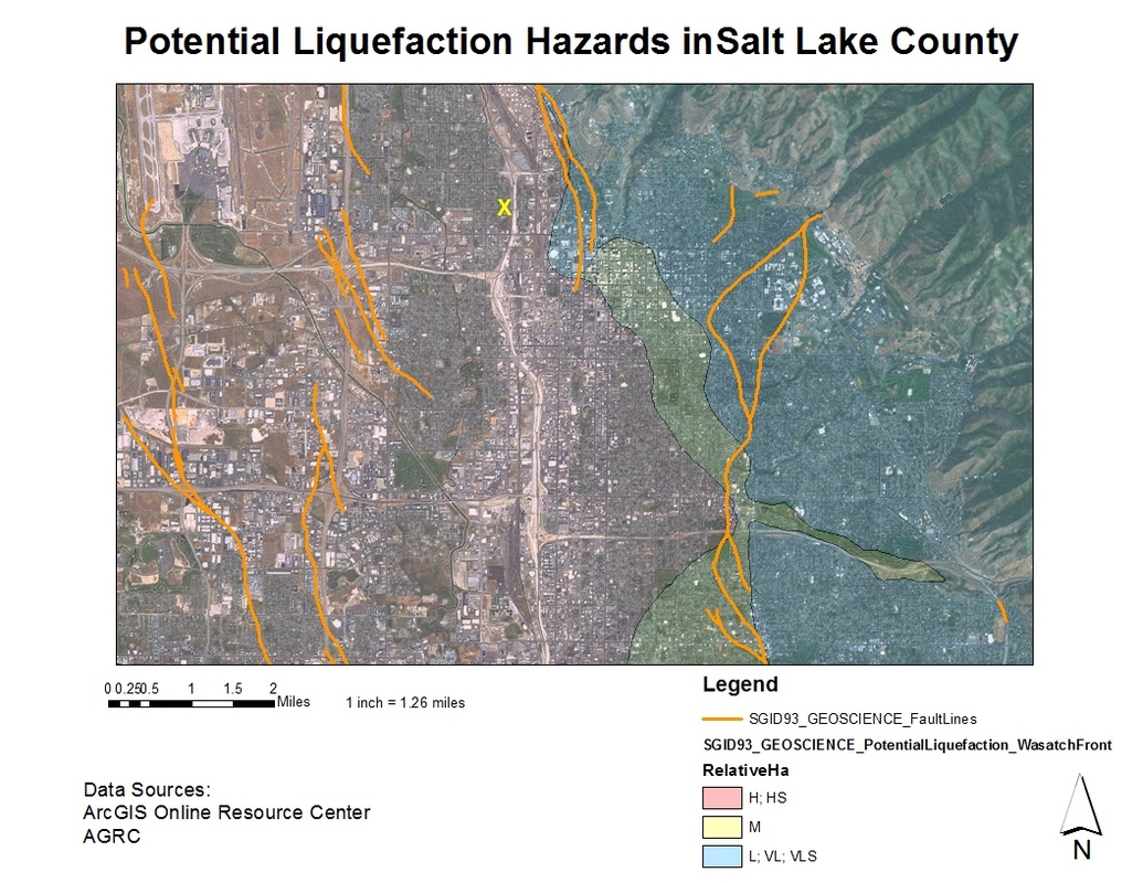
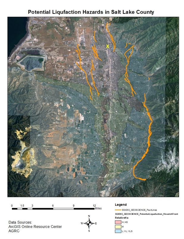
Liquefaction potential in Salt Lake County
Why is liquefaction a concern? Liquefaction has caused significant property damage in many earthquakes around the world, and is a major hazard associated with earthquakes in Utah. The 1934 Hansel Valley and 1962 Cache Valley earthquakes caused liquefaction, and large prehistoric lateral spreads exist at many locations along the Wasatch Front. The valleys of the Wasatch Front are especially vulnerable to liquefaction because of susceptible soils, shallow ground water, and relatively high probability of moderate to large earthquakes.
Where is liquefaction likely to occur? Two conditions must exist for liquefaction to occur: (1) the soil must be susceptible to liquefaction (loose, water-saturated, sandy soil, typically between 0 and 30 feet below the ground surface) and (2) ground shaking must be strong enough to cause susceptible soils to liquefy. Northern, central, and southwestern Utah are the state's most seismically active areas. Identifying soils susceptible to liquefaction in these areas involves knowledge of the local geology and subsurface soil and water conditions. The most susceptible soils are generally along rivers, streams, and lake shorelines, as well as in some ancient river and lake deposits.
How is liquefaction potential determined? The liquefaction potential categories shown on this map depend on the probability of having an earthquake within a 100-year period that will be strong enough to cause liquefaction in those zones. High liquefaction potential means that there is a 50% probability of having an earthquake within a 100-year period that will be strong enough to cause liquefaction. Moderate means that the probability is between 10% and 50%, low between 5 and 10%, and very low less than 5%.
By Loren R. Anderson - Utah State University, Jeffrey R. Keaton - SHB AGRA, and Sandra N. Eldredge - Utah Geological Survey
From Utah Geological Survey http://geology.utah.gov/utahgeo/hazards/liquefy.htm
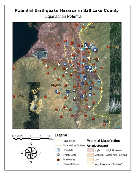
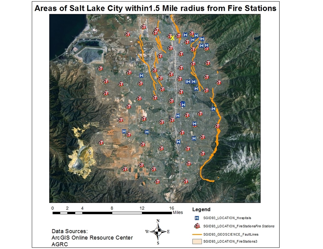
Maps showing ground shaking, liquefication, and landslide potential in Salt Lake County
How earthquakes look from space
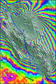
Satellite-based, interferometric synthetic aperture radar measurements: This image shows ground displacement in the October 1999, Mw 7.1 Hector Mine Earthquake, Southern California. Each color represents 2.5 cm of motion of the ground in a direction towards the satellite. (Research by: Prof. Mark Simons, Yuri Fialko & Luis Rivera) - image credit California Institute of Technology
Wasatch Fault Flyby (YouTube)

Additional Earthquake Information
Wasatch Fault http://geology.utah.gov/online/pdf/pi-40.pdf
Earthquake Information General Education Tools http://www.seismolab.caltech.edu/gen_eq_info.html
Utah Department of Natural Resources Utah Earthquakes & Geologic Hazards
USGS - U.S. Geological Survey Earthquake Hazards Program
Southern California Earthquake Data Center http://www.data.scec.org/
Caltech's Seismological Laboratory http://www.seismolab.caltech.edu/
University of Utah Seismograph Stations http://www.seis.utah.edu/
Deseret News - Would Utah be ready to withstand a disaster?
http://www.deseretnews.com/article/605153890/Would-Utah-be-ready-to-withstand-a-disaster.html
FEMA http://www.ready.gov/earthquakes
GeoScienceWorld http://www.geoscienceworld.org/
Seismological Society of America
3D Simulations of M 7 Earthquakes on the Wasatch Fault, Utah, Part I: Long-Period (0–1 Hz) Ground Motion 2351, WASATCH FAULT ZONE
